Thursday, December 11, 2008

Taylor Dome Part 2

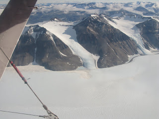
A shot of one of the Dry Valleys.


Our toilet in the poop tent.


This shot was taken just as we crossed over the coast of Antarctica. A lava field takes up most of the shot. We weren't quite sure what that circular region was, but we thought it looked cool. I was thinking it may be some sort of lagoon with shallow ice over it, but I really don't know.


I'm standing in this shot. You can see the solar panel frame for the primary pulsar. The white PVC tube sticking out of the ground is the top of the bore hole. The solar panel box has cables that go to a battery box, which is under the surface of the snow. The pulsar box is barely visible near the bore hole, and it has a cable running down the bore hole to an antenna.


Anne, our mountaineer, decided to have a drinking contest with me right before we went to bed one night. My water was starting to freeze, which made for an unpleasant experience. I won, but I had a little bit of a head start and I weigh probably twice as much as she does.


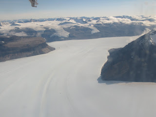
I don't know which glacier this is, but you can see how it flows.


I thought this was Mount Discovery, but now I'm thinking it wasn't, so it's just another photo.


This is an candid photo of myself. My neck was actually pretty sore, which was why I was laying down. I think not being able to stand up in any of the tents, having to look down to walk because of the goggles, and all the stuff in my jacket that I didn't want to freeze contributed.


Adding the secret ingredient to Sastrugi Stew.

Tuesday, December 9, 2008

Various Photos


The panel on the battery box facing the center column before it was put on.


A Science Support Center worker's toy.


We are actually still doing some work on ANITA. I finished taping up the instrument. It is special teflon tape, much like they use on satellites, that is extremely reflective, and of course costs a lot of money. The tape on the ANITA instrument probably totals over $3,000. Other people are still working on calibrating the antennas, and we made another addition which you will see more clearly in the next shot. The cover is off of the NASA instrument, so you can see inside it, I believe that instrument is worth $1 million. Soon the gondola will only be sitting on my stand, as apparently the hoist is due for it's annual service. It will be neat and nerve wracking to see. At this point the gondola is obviously priceless, but to give you an idea of it's actual cost, each of those square white antennas costs $5,000 and there are 40 of them. The lower ring of solar panels(which isn't on in this photo) costs over $30,000. The instruments are even more ridiculous.


Looking back towards the back half of our hangar. I'll get a better shot when payload is out of the building.

Observation Hill Hike


Observation Hill, or Ob Hill is a prominent hill near McMurdo that you can hike at any time when the weather is good, and because it is always sunny, you can really hike it at any time. I'll get a better shot of it, so keep reading my blog.


At the top of the hill, which is about 750 feet high, there is a cross dedicated to the members of Robert F. Scott's expedition to the South Pole as due to poor planning and luck none of them made it back. Scott base is named after him, as is Amundsen-Scott, the U.S. base at the South Pole. After being here and experiencing the best Antarctica has to offer, the hardships they face are still almost incomprehensible. In fall of 1911 they began their trek with motorized vehicles, dog sleds, and horses. These all traveled at different rates which made the expedition difficult and it was compounded by the fact that they didn't know how to lead the dogs, so the men ended up pulling the sleds and the dogs ran along beside them. They made it to the South Pole five weeks after Amundsen and so they began their trek back. One member of the team fell off of a glacier, another was so injured that walked off into nothingness after saying "I am just going outside and may be some time" in the hopes that he would no longer jeopardize the lives of the other members of the team. By March of 1912 bad weather set in, and the remaining members made it 11 miles past where a resupply depot was supposed to be, but 24 miles short of the actual location of the depot. The ended up just hunkering down and eating through their last supplies as storms, poor health, and decreasing sunlight made progress impossible. He kept a really interesting journal, which is why he is remembered and revered today. Amundsen hardly wrote anything interesting about his expedition, but later said that "I would gladly forgo any honour or money if thereby I could have saved Scott his terrible death." The cross was erected in 1913, and part of it's inscription reads " To strive, to seek, to find, and not to yield."
Scott Base, the Kiwi base.


Mactown.


Those mountains form the coast of Antarctica proper, but as you can see, it's just ice between Ross Island, where McMurdo is, and the continent.

Monday, December 8, 2008

Battery Box Art

The battery box contains the batteries for the flight. There is fluctuation in the intensity of the sunlight during the flight, so the batteries help ensure a consistent supply of electricity. The batteries need to be kept warmer than the ambient temperature at 100,000 feet, which is actually pretty close to freezing. To accomplish that, the panels covering the box need to be between 40 and 60 percent black. Last time they had an art contest with the winners get a monetary prize as well as the opportunity to see the balloon launch. This year they tried the contest again, but for whatever reason we didn't get sufficient entries, so two of the panels were done in house. I don't have a photo of the top panel, but I'll try to get one.

I'll also try to get a better shot of this panel.


More than a few random shots


This is a shot of us coming back from the balloon base on the Saturday following Thanksgiving. Thankfully they didn't close the road until after we made it back, so I was able to get Thanksgiving dinner. There are two vans in this shot fyi.


This is looking into one of the instruments on the deck of the gondola. It is the heart of the experiment.


One laptop isn't enough for some people I guess.


Here you can see the other physics experiment, CREAM, doing their hang test.


ANITA outside of our hangar to practice a hook to hook transfer. The bottom antennas actually swing out after launch, and they are referred to as drop down antennas from here on out. The solar panels are also not on as they are extremely fragile which makes putting them on extra fun for me.


This is the freezer for the galley at the balloon base.


ANITA sitting out on a pad doing GPS testing and calibration. GPS is used to figure out the exact position and orientation of the payload as well as to provide extremely accurate timing.


ANITA during the hang test. The drop downs are retracted in this photo.


ANITA in all her glory with the drop downs deployed. The saucer like antennas at the top on the corners of the solar panels are the GPS antennas. The instrument on the deck on the left is the heart of ANITA. The battery box is on the far side, and NASA's instrument which monitors the flight and controls the ballast hopper, balloon valves, and other aspects is on the right. We passed the hang test, and ANITA weighed in at 5585 pounds including with one person on board and the temporary protective solar panel covers on.

Thursday, November 27, 2008

Happy Thanksgiving

Thanksgiving here is celebrated on Saturday, so today was just a normal day. The chef at the balloon base decided to cook a Thanksgiving meal for us tomorrow, but apparently the weather may worsen in which case we may not be able to go to the balloon base.

The weather has been deteriorating this evening, but it really isn't as bad as it looks in this photo.


That's my building. My room is on the first floor, probably the third window from the left.

Wednesday, November 26, 2008

Taylor Dome Part 1

Again, this will be a two post night. I say Part 1 because I hope to exchange pictures with people so that I may actually have photos of me to post. I have a few more photos that for some reason I can't post, so I'll work on that as well.

I just returned from a five day trip to Taylor Dome on Antarctica proper. Taylor Dome wasn't as much of a dome as I would have expected, but you could tell the horizon was nearer in certain directions, so there was some slope to the topography. Central Antarctica is a high plateau, while the coast is pretty rugged. Taylor Dome is at the beginning of the plateau. It's an amazingly desolate place. Roughly 700 miles of flat windswept snow stand between Taylor Dome and the South Pole.

We were at roughly 8500 feet, but because of the rotation of the earth, the atmosphere gets spun out towards the equator and gets thinner at the poles, so the physiological altitude was close to 10500.

The temperature was pretty moderate, only dropping to -30 degrees F or so, but the wind could be brutal. It didn't take long after I removed my gloves to tie a knot or work with connector for my hands to be pretty cold. For your information, toothpaste is still liquid at -30 F, but just about everything else freezes except for fuels. However, when you brush your teeth, the toothpaste you put in your mouth is at -30 F. Again it is always sunny here, the sun never sets, so it makes work easy as you don't have to worry about it being dark. You also don't have to worry about bears getting into your food or anything.

I traveled with two scientists and a mountaineer. The purpose was to set up a remote autonomous antenna that will broadcast a signal every second that can be used to calibrate the gondola when it is in flight. The antenna that is used to broadcast the radio signal, is down a 300 foot borehole in the ice. The ice is about half a mile thick where we were, but it doesn't become more comfortable the thicker it gets.

It was truly an amazing experience, I have a lot of stories about it, but it definitely had it's moments. There wasn't a time when I wanted out, but I definitely spent some time thinking about sitting on a beach in Hawaii.

I have done camping before, but I don't know this was definitely different. Melting snow for water took hours every day, everything freezes, high altitude, blowing snow, low visibility, total dependence on others for our survival as there was now way we could reasonably survive without a plane flight out, and the feeling of being the only people within a 150 mile radius are a few of the aspects of the adventure that stood out.

One short story I'll share now. I brought a pair of ski's along, as the mountaineer traveling with us spent 62 days skiing across Antarctica with her gear in the first all women's group to make it to the pole from the edge of the continent, and I felt that there wouldn't be a better place to learn to ski, or a better instructor. I won't say that I learned to cross country ski, but I didn't fall down, and was able to get around fairly well. I don't think there will be any photos of that, but it was a neat experience.

This most certainly was a trip of a lifetime, many people have come to Antarctica for years, and have never gotten to fly over the continent let alone camp with such an amazing mountaineer on the Antarctic Plateau. I have been very lucky, this whole trip has been pretty spectacular to say the least.
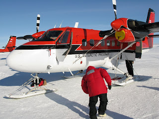


The Twin Otter we flew in. They are amazing planes that can take off at 45 knots. The pilots are also really impressive, but they probably have one of the greatest jobs in Antarctica, stunning scenery, minimal air traffic, and a good deal of appreciation by everyone they pick up.
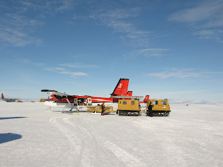


The tracked vehicle in this photo is a Haglund, I've never ridden in one, but I can walk faster than them sometimes.


The outside of my window was icy, so these first few shots aren't too clear. In the background is Mt. Erebus, in the foreground you may see a big white circle on the right, that is the balloon launch pad. From this perspective, if the circle was a clock face, the balloon base buildings are sort of where the hour hand would be at 9:15. You can also see the runways for Willy Field, where I took off for this trip.
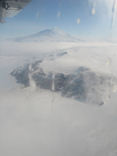


This is a shot of part of Ross Island. Mt. Erebus is in the background, McMurdo is sort of in the middle, you get points if you find it.


This is a close up of McMurdo. I apologize for not taking photos around base yet, but I'll work on getting that done.
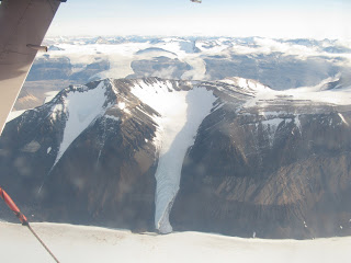


These next few shots are from the window in front of me, the glass was cleaner, but I had to contort myself to get them. These are all above Antarctica proper.
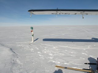


This is the bore hole that we were for, well at least the cover of it. It was left almost two years ago.
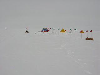


This is a shot of our camp.
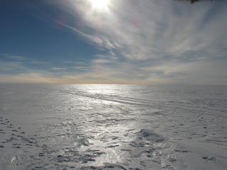


This is looking out onto the Plateau.